

 Residents from the Ohio Valley to the mid-Atlantic and New England coasts should be prepared in case of tropically-enhanced rain and flooding occurring next week.
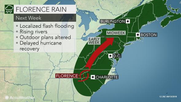
While Hurricane Florence will spend days in the South, AccuWeather meteorologists believe that the storm will survive long enough to bring rounds of heavy rain and the risk of flooding to the central Appalachians and northeastern United States next week.
Some shower and thunderstorm activity not directly associated with Florence is in store from the upper mid-Atlantic and central Appalachians to New England through this weekend. These slow-moving downpours on their own can cause isolated flash flooding.
There is the potential for a general 3-6 inches of rain from Kentucky, West Virginia and Southwest Virginia to Maine even days after Florence moves ashore.
“While those living in the Appalachians should monitor Florence’s track, the center of the system may not track right over the mountains, rather it could track either west or east of the mountains,” according to AccuWeather Meteorologist Courtney Spamer.
“Because of this, residents from the Ohio Valley to the mid-Atlantic and New England coasts should be prepared in case of tropically-enhanced rain and flooding occurring next week.”
Areas in the West Virginia, SW Virginia, western Maryland and the Pennsylvania mountains are likely the most vulnerable for flash and stream flooding, due to the saturated state of the ground, proximity to tropical moisture and the terrain.